 |
|
|
|
|
 The Greek archipelago, serving as a bridge to link East and West, a crossroads
and a meeting-point for three continents - Europe, Asia, Africa - and three different
worlds, was the birth-place of the most ancient civilisations. For centuries it attracted
peoples to settle within its borders and was bustling with life at periods when mainland
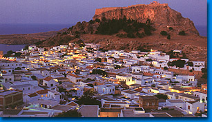
Greece was in decline.In this world, at its south-eastern extremity, lies Rhodes, the
fourth largest of the Greek islands. It has an area of 1,398 sq. km, belongs to the
Dodecanese group of islands, is 246 nautical miles from Piraeus, and, has a permanent
population of 100,000. Its shape is elliptical, and it has a maximum length of 77 km.,
while its greatest breadth is 37 km. The Greek archipelago, serving as a bridge to link East and West, a crossroads
and a meeting-point for three continents - Europe, Asia, Africa - and three different
worlds, was the birth-place of the most ancient civilisations. For centuries it attracted
peoples to settle within its borders and was bustling with life at periods when mainland
Greece was in decline.In this world, at its south-eastern extremity, lies Rhodes, the
fourth largest of the Greek islands. It has an area of 1,398 sq. km, belongs to the
Dodecanese group of islands, is 246 nautical miles from Piraeus, and, has a permanent
population of 100,000. Its shape is elliptical, and it has a maximum length of 77 km.,
while its greatest breadth is 37 km.A 47 km channel separates it from the island of Karpathos and a narrower one, of 37 km, from the coast of Asia Minor. Rhodes, like the rest of the islands of the Aegean, was created by the fragmentation of Aegis, the continent which extended from the Ionian Sea to Asia Minor and the northern coast of what is now Crete. The island's terrain is mountainous. Its rocks, which are of limestone and schist, form a mountain backbone in the centre of the island: Mt Atavyros with its peaks - Akramytis in the south-west, 823 m. at its highest point, Atavyros in the middle at 1,215m, and Profitis Ilias to the north. The mountain mass gives place to plains which are of limited area, but fertile. The island's coastline is indented with innumerable beaches, mostly sandy, wide bays, and headlands, such as Zonari in the north-east on which the city of Rhodes stands - Lardos or Fokas in the east, Armenistis in the west, and Prassonisi in the south. The latter is joined to the rest of the island by a narrow spit of land and becomes an islet when the sea level rises. Rhodes has a Mediterranean climate, with an average temperature of 18 - 20", mild winters, and cool summers (thanks to the cooling north-easterly which blows in the summer months). It has a high number of hours of sunshine (some 300 days a year) and high humidity. 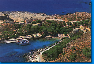 It is the sunshine and humidity that
account for the island's lush vegetation. Rhodes, though mountainous, is green all over,
the only exception being the area around Mt Atavyros, which underwent deforestation during
the period of Turkish rule as a result of uncontrolled woodcutting. |
(c) 1999 RodosNet. Designed by Spyros Spyropoulos |
|